Scientific articles

Evaluare: 0 / 0 vote  
Easy to use tools for ICZM progress reporting and coastal indicators
Dimensiune fișier:
4.89 MB
Versiune:
Published online on 08 March 2014 in J Coast Conserv (ISSN 1874-7841)
Licență:
© Springer Science+Business Media Dordrecht 2015
Autor:
Black Sea Commission Permanent Secretariat and GeoGraphic
Email:
MGvilava[at]GeoGraphic[dot]ge
Data:
30 Mai 2015
This paper describes the software tool developed for the application of the European ICZM colour coded progress markers, as fine-tuned for the Black Sea region. More information can be found at http://www.iason-fp7.eu/project_uptakes.The final publication is available at Springer via dx.doi.org/10.1007/s11852-015-0375-y. Installation package and small demonstration video are accessible through IASON Knowledge Base at http://iason-fp7.eu (see respective entries at Toolkits, Videos).
 
Evaluare: 0 / 0 vote  
Prerequisites for Developing Geospatial Data Infrastructure in Georgia
Dimensiune fișier:
13.54 MB
Versiune:
1.0
Licență:
License: Creative Commons Attribution-NonCommercial-ShareAlike 4.0 International
Autor:
Email:
MGvilava[at]GeoGraphic[dot]ge
Data:
14 Mai 2015
This paper contains the extended abstract and the poster displayed at the EOPOWER special poster session of GEOBIA 2014 and included in the special thematic issue of the South-Eastern European Journal of Earth Observation and Geometrics Vol 3, No 3S (2014), available at following link http://ejournals.lib.auth.gr/seejeog/issue/view/727. Technical and institutional prerequisites for developing the geospatial data infrastructure in Georgia are analyzed. Current state of the geospatial data infrastructure is assessed on its compatibility and potential compliance with themes addressed by INSPIRE. Recommended steps include the further development of the institutional coordination mechanism between agencies thematically involved in various GEO Societal Benefit Areas.
 
Evaluare: 0 / 0 vote  
Empowering Economic Development in the Balkan Region
Dimensiune fișier:
194.28 kB
Autor:
Email:
antic[at]uns[dot]ac[dot]rs
Data:
30 Octombrie 2014

[This document is an extended abstract of the articile]

The development and expansion of the urban tissue of the historical capital of Cyprus Nicosia over the years is studied through historical documents, maps, archived aerial photographs and recent satellite imagery. Documentation tools and the current technology of visualization is been used as a means for dissemination of the derived information to non-experts and the wide public. The case of Nicosia is quite indicative for a big number of city centers suffering from a similar problem: to keep a balance between a long historical evolution and enhance the public awareness from one hand, and revitalize a living urban center on the other hand. We feel that the contribution of photogrammetry, remote sensing and visualization techniques can be enormous and we intent to make a case through the Nicosia case study.

 
Evaluare: 0 / 0 vote  
Paving the way toward an environmental National Spatial Data Infrastructure in Armenia
Dimensiune fișier:
3.00 MB
Versiune:
http://www.unige.ch/envirospace/People/guigoz.html
Autor:
Yaniss Guigoz
Email:
yguigoz[at]unepgrid[dot]ch
Data:
30 Octombrie 2014

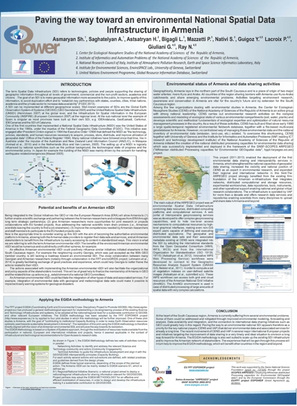
Being integrated to the Global initiatives like GEO or into the European Research Area (ERA) will allow Armenia to (1) further enable scientific exchange and partnering between the Armenian researchers and colleagues from ERA through long term strategic partnerships; (2) give Armenian researchers more opportunities for joint research or projects collaborations with EU funded projects, thus addressing the national scientific brain drain problem (i.e., Armenian scientists leaving the country to find a job elsewhere); (3) improve the competencies needed by Armenian researchers and staff members to participate to the EU funded projects calls.


Online bookmaker the UK http://whbonus.webs.com/ William Hill
http://bigtheme.net/wordpress